New Progress in Estimating Soil Thickness on Karst Dolomite Slopes
Recently, significant progress has been made in the study of soil thickness estimation on karst dolomite slopes by the research team led by Prof. Wang Kelin from the Institute of Subtropical Agriculture, Chinese Academy of Sciences, in collaboration with the Institute of Mountain Hazards and Environment, CAS, and other institutions. The study was conducted at the Huanjiang Karst Ecosystem Observation and Research Station in Guangxi. The findings have been published in the international journal Catena.
Karst regions are characterized by shallow and highly heterogeneous soils, which are key limiting factors for vegetation restoration and ecological project siting. Traditional methods such as soil probes and electrical resistivity surveys are often affected by bedrock interference and struggle to accurately estimate “ecologically effective soil thickness.” Based on the contrasting radiation characteristics—low radioactivity in bedrock and high radioactivity in soil—the researchers established, for the first time, a power function model relating soil thickness to gamma radiation dose rate (R² = 0.99) (Figure 1). This provides a simple, non-destructive method for rapidly estimating shallow soil thickness.
To validate the method, a standard soil-filled test box was constructed on a dolomite bedrock slope, and gamma dose rates were measured in layers across a range of soil thicknesses. The results confirmed high sensitivity of gamma values to soil thickness within the 0–35 cm range. Field tests showed that the average estimated soil thickness was only 0.47 cm in grassland plots and 11.22 cm in shrubland plots—closely matching previous large-profile excavation data, and providing more realistic estimates of “ecologically effective soil thickness” than the steel probe method (Figure 2). The study highlighted that this method is particularly suitable for assessing vegetation restoration potential and delineating afforestation suitability zones in rocky desertification areas.
This innovative approach offers valuable technical support for soil resource surveys, optimizing ecological restoration models, and regional planning for rocky desertification control in karst landscapes. Future research could integrate this method with remote sensing imagery and geoelectrical imaging to produce large-scale soil spatial distribution maps.
Contact:Yuemin Yue
E-maill:yueym@isa.ac.cn
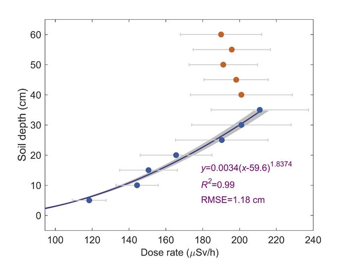
Figure 1. Relationship between gamma radiation dose rate and soil thickness(Imaged by Wang Lu)
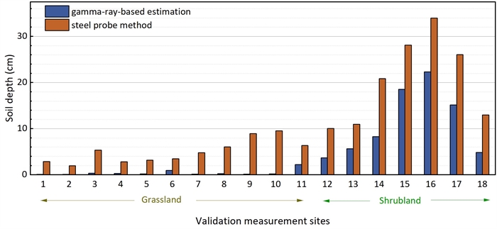
Figure 2. Comparison between gamma-ray soil thickness estimation and steel probe method(Imaged by Wang Lu)